The COST Action TD1403 “Big Data Era in Sky and Earth Observation” (BigSkyEarth) is a trans-disciplinary network involving researchers, scientists and representatives of some companies involved either in the observation of the sky or in the observation of the Earth. Although the nature of their research differs significantly, these two communities share a common interest towards the application of remote sensing approaches dealing with the production, storage and processing of big data supporting sky and earth observations. Accordingly, BigSkyEarth aims at boosting the communication within and between these scientific communities by identifying and clustering relevant common solutions developed within research and industrial environments.
Intelligent Transport Systems (ITS) is a relevant application domain for remote sensing and big data approaches discussed within the Action. As such, ERAdiate activities were considered of high interest to this community. To identify common ground for potential collaboration, Dr. Lugano was invited to give a talk at the workshop on “ERAdiate: Fostering Interdisciplinary Research and Innovation on Intelligent Transport Systems at the University of Žilina” (presentation available at http://www.erachair.uniza.sk/activities/conferencespresentations). The workshop was organised in the picturesque town of Sopron, in Hungary, and was attended by about 40 participants from several European countries participating in the COST Action.
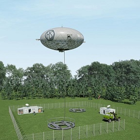
The presentation generated interest both towards the ERAdiate project and more generally towards the ERA Chair funding scheme, which was not very well known by the Action participants. Areas of common interest were identified, such as the possibility of enabling ITS services in rural areas with the support of aerial positioning technologies such as Hipersfera airships http://hipersfera.hr. As illustrated by Dejan Vinkocic (Chair of BigSkyEarth) and Bojan Pecnik, such airships have an ability to persistently and cost-efficiently perform critical real-time tasks previously considered technically impossible or economically unfeasible. Airships operate at 1 to 5 km above sea level and can flight up to four days, covering an area of 40 to 230 square kilometres of terrain with high-resolution optical and thermal sensors. Additional sensors (e.g. SAR, visual and infrared cameras, hyperspectral cameras, LIDAR) can be integrated depending on the application needs. In short, this type of airships leverage the advantages of geostationary satellites (persistent oversight) and unmanned aerial systems (flexibility and scalability), at much lower costs.
The workshop also included talks on horizontal issues, such as the one by Andrea Manieri on the emerging profession of data scientist and the data science skills needed in Earth observation, and the talk by Srdan Mitrovic on interdisciplinary education for big data signal processing.